How did I make these cool bike ride pictures? Well here is how. You need a Garmin bike GPS. I have the Edge 205 (or newer and more expensive if you like). Garmin has two programs that you can use for mapping your tracks. One is Map Source, the other is Training Center. You can download both from the Garmin web site, and you need the more current versions. I have Map Source 6.13.7 and Training Center 2.4.3.
After plugging your GPS into your PC, installing all of the software and drivers etc.(I won't get into that here for obvious reasons) you can view the tracks in either program.
Training center allows you to graph speed and elevation, grade, pace, etc. Once the Training Center program has the graph I want, I use Alt-Print Screen to capture my desktop, the a graphics program (you could use paint if you have nothing else) to paste from the clipboard, then crop out the selected chart and save it as a .jpg.
Then download and install Google Earth. You should do this anyway. It is cool. Below I will refer to the Places navigation panel of Google Earth:
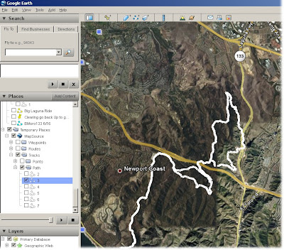
Map Source also has an option to download info from the GPS. After you do this, select the tracks tab so you will know what is going to be displayed in Google Earth, then select the View, View in Google Earth menu option. It takes a while and a fast PC that has decent memory. It loads a bunch of stuff into Google Earth in your Temporary Places folder, in a sub folder MapSource. You really don't want most of the stuff, it is confusing and excessive. Uncheck the Temporary Places folder so it all disappears, then expand the MapSource folder, then the Tracks folder (in the MapSource folder, then the Path folder (in the Tracks folder). Then click on the track number you want to map, and it will appear. You can then right click on it to change the properties of the line (which is a good idea to make it narrower and more precise). Also you can rename it and save to My Places (also right click).
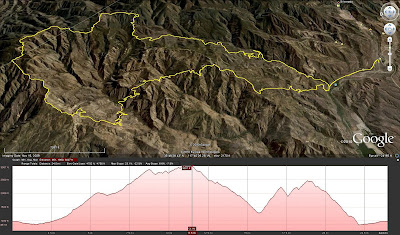
UPDATE (Nov 2010). Google earth now has an option to show the elevation profile of a selected track:
Have Fun!


